Student Research
In FY22, KansasView enhanced the Sentinel GreenReport to allow users to define areas of interest to visualize and explore vegetation condition and change (shown below). First, the users define an area of interest (AOI) using rectangle, polygon, point, or line geometries. Second, the data are dynamically summarized in the GEE cloud to produce a chart showing a smoothed interannual NDVI time-series for the AOI. And third, the proportion of land cover are calculated for the AOI and presented as a chart series using the annual USDA NASS Cropland Data Layer land cover product.

In 2021, KansasView funded a graduate student to develop the Sentinel GreenReport application leveraging Google Earth Engine to measure and monitor vegetation across the United States. There are four maps created from the Sentinel-2 archive. Greenness Map-represents NDVI, which is a surrogate for photosynthetically active plant biomass, for a user-defined composite period; Difference Map 1-compares NDVI to the previous composite period within the same year to illustrate recent vegetation change; Difference Map 2-compares NDVI to same period from the previous year to examine year-over-year vegetation change; Difference Map 3-compares current NDVI to the average NDVI from previous years to examine vegetation change relative to the recent average. These maps can be used for a wide range of applications such as crop monitoring and disaster assessment (lower right).

Non-Student Research
NEON Data Exploration: The National Science Foundation’s National Ecological Observatory Network (NEON) collects and provides long-term open access data to explore and understand continental ecosystems. The KU Field Station is the satellite site to the Konza Prairie which represents the Prairie Peninsula domain. During peak productivity, NSF’s Aerial Observation Platform (AOP) collects LiDAR, hyperspectral imagery, and high-resolution aerial imagery on an annual basis. Numerous indices and data products are then derived and made available through the NEON Data Portal. To explore data availability, quality, and utility, KansasView has compiled multi-year datasets for the KU Field Station that can be explored and visualized in a WebApp (link below). These data will be presented and shared with researchers in an effort to explore potential future research opportunities.
NEON Airborne Observation Platform (AOP) data acquired at the Kansas University Field Station (KUFS) WMA: https://ku.maps.arcgis.com/apps/webappviewer/index.html?id=65508da0ffcc461abfba22fa7b54cda7
For more information on NEON’s AOP remote sensing data: https://www.neonscience.org/data-collection/airborne-remote-sensing
Potential Wetland Area (PWA) Database: Using LiDAR-derived digital elevation models (DEMs) and terrain layers, a topographic wetland identification process (TWIP) has been developed to map potential wetland areas in Kansas. KansasView is leveraging and building upon existing mapping efforts to complete the PWA database for Kansas. The are available on the Data Access and Support Center (DASC), the state’s repository for geospatial data at https://www.kansasgis.org/ To access data you will need to create a user login profile. To find the PWA database, go to Catalog–>Environmental Resources–>Potential Wetland Areas. Users can also explore the PWA database by the newly created Dashboard: https://ku.maps.arcgis.com/apps/dashboards/168959bac666442fb155b50ffa813064
Student Research Grants
KansasView continues to offer small research scholarships to students attending our consortium institutions. Below is a summary of recently funded student research projects
Hilda Onuoha, Ph.D. Candidate in the Department of Geography at Kansas State University used the KansasView mini-grant to work with Dr. J.M. Shawn Hutchinson on the project titled, “Time Series Analysis of Phenometrics and Long-Term Grassland Trends across the Great Plains Ecoregion Using Moderate Resolution Satellite Imagery“. Below is a summary of the research approach and current activities.
MODIS MOD13Q1 16-day maximum composite value NDVI image products were acquired for the period 2001-2017 (250 m spatial resolution, n = 391 images). Using the 2011 NLCD product, spatially resampled pixels of the “grassland/herbaceous” class were used to mask MODIS imagery to retain for analysis only those 250 m pixels comprised of a majority of grassland types and within the Great Plains Level 2 ecoregion.
Phenological analysis was conducted using the program TIMESAT and included quality data provided by the MOD13Q1 pixel reliability band. Temporal decomposition was performed using the Breaks For Additive Seasonal Trend (BFAST) routine which is based on a LOESS driven STL temporal decomposition. BFAST also models the trend component which permits detection of breakpoints, including when the break occurred and its magnitude. Phenometrics and NDVI/EVI trends data have recently been computed using the Beocat High-Performance Computing (HPC) cluster at Kansas State University. Current activities are focused on additional statistical analysis to better evaluate spatiotemporal trends.
In 2018, the research was presented at the 3rd Joint European Association of Remote Sensing Laboratories and NASA Land use/Landcover Change Workshop. Two publications detailing NDVI and EVI trends over the 2001-2017 period and a summary of current phenological measures of vegetation development are in progress and will be submitted later in 2019.
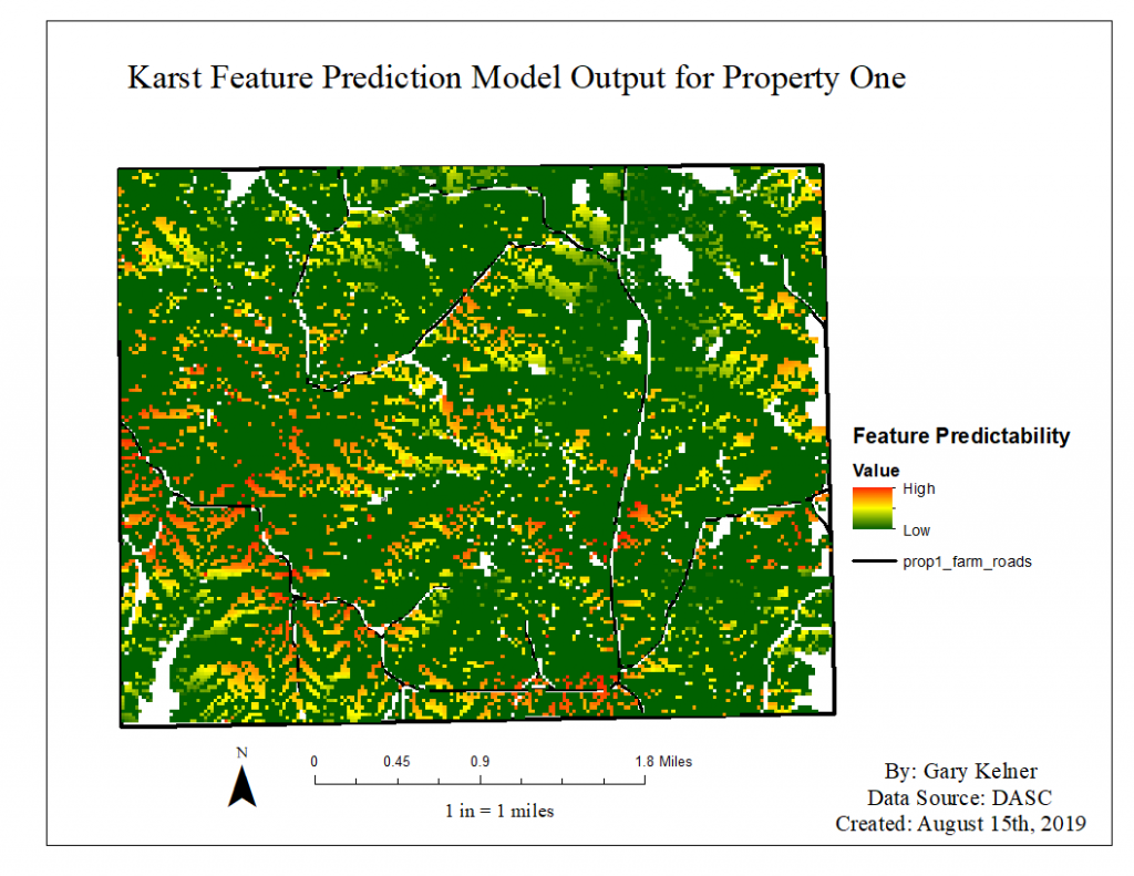
Gary Kelner, Ph.D. candidate from Fort Hays State University used a KansasView mini-grant for his research on Karst Feature Predictability Modeling in southern Kansas. Landsat 8 and LiDAR data were used in the predictive model. The funding helped in the reconnaissance of the karst features to test his model. Gary presented his research at the Geological Society of America 2019 Annual Meeting in Phoenix, Arizona in September 2019.